Valles Marineris:The Past |
||||||
V. The PastNumerous hypotheses and theories exist as to how the huge, 4000 kilometer-long scar that is Valles Marineris was created. Three of which are easily and continually supported by observed evidence, and thus designated "major" theories. The others are either a combination of major theories or are more radical and thus designated as "minor" theories. However, before each theory can be presented, the constituent processes must first be induced and examined.Va. Geologic RecordDating of Martian surfaces is done by way of measured crater flux rates using the moon as a known baseline. While it may be possible to obtain very approximate absolute age ranges on Martian surfaces by extending lunar parameters to Mars, there are too many unknowns and large uncertainty values that would make these numbers almost useless (Malin, M.C. and Edgett, K.S., 2000). However, relative ages can be determined as long as sufficient craters are available, otherwise the data again becomes unreliable.Dating of layered outcrops is unsurprisingly determined through stratigraphic and crosscutting relationships (Malin, M.C. and Edgett, K.S., 2000). Vb. Tectonic Events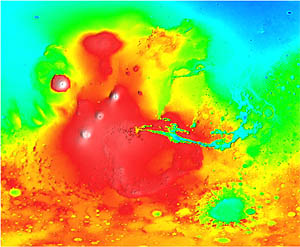 Figure 8: Relative altitude of Tharsis - Valles Marineris area. Red represents high altitudes, blue represents low altitudes. Credit: NASA/GSFC/Laboratory for Terrestrial Physics One possible explanation for the upwelling in the Tharsis area (the relevance of which will later become evident) is that there may be a single, large mantle plume upwelling into this area, fitting gravimetric and crustal thinning observations (Harder, K. and Christensen, U.R., 1996). Harder and Christensen's modeling has shown in two dimensions that an endothermic phase boundary, caused by chemical fractionation, in the lower mantle and above the core would greatly alter convection patterns, possibly resulting in one or two plumes given sufficient time. Their recent three-dimensional modeling of this same process confirmed their earlier results, and additionally noted that the remaining plumes remain stationary and do not migrate. However, their simulations note that the single plume is much larger size at 7.8 billion years after planet accretion than it is at 4.5 billion years, therefore implying the stresses and volcanics in this area should only increase. Alas, a possible explanation for this is the cooling of the Martian mantle over time. There are three sets of faulting seen created by the Tharsis stress field (Schultz, R.A, 1991). One set is geometrically centered in Syria Planum, and the other two sets (Pavonis I and II) are centered near Pavonis Mons. Schultz (1991) determined that faults seen in and around the Valles Marineris are the same as those as Pavonis I. Vc. Major TheoriesFrom the observations at hand, it is now possible to derive possible major theories for the creation of Valles Marineris. The first of which, is the erosional theory.The voids left behind in the canyon system represents huge amounts of mass that would need to be removed (Malin, M.C. and Edgett, K.S. 2000). By performing some calculations, Schultz (1991) determined the approximate amount of material unaccounted for by the voids represented by the main troughs is close to 3 x 10^6 km3. He is also able to conclude the maximum age for a large erosion event to be in the Late Hesperian. Pure erosional theory states that all this missing material had to be removed by wind erosion, surface water flow or mass wasting (typically landslides). An obvious problem with this theory is it provides no details on an initiating event or set of circumstances, and does not explain why this phenomenon is not seen elsewhere on Mars to this vast degree. The collapse model for the creation of Valles Marineris however does provide an initiating event. In this process best described by Schultz (1991), fractures attributed to the Tharsis stress field unsteadies the area in question. Subsidence and collapse then occur from ground water/ice retreating and/or magma withdrawal. Macroscopic observations would show this starting out with the formation of pit craters, resulting from internal collapsing, and having them slowly grow, merging with other pit chains, eventually forming troughs as they are seen today. However, even Schultz makes the point that pit craters and chains are structurally and morphologically different from large troughs, implying that other processes may be at work. A variation of the collapse theory is the Keystone collapse model (Schultz, R.A., 1991), based upon the idea of lithospheric stretching directly underneath Valles Marineris and the large amounts of normal faulting and graben formation that would be associated with such an event. In a refreshingly succinct analysis, McKenzie and Nimmo (1999) hypothesized on the effect of large dyke intrusions. With such large amounts of volcanics associated at one time in this region, coupled with the fact that the Valles Marineris is radial to the Pavonis I Tharsis fault system, their assumption is a plausible one. In their study, they indicated such dykes could provide enough heat to melt ground ice, and over a large enough area to mobilize enough water to account for the present-day topography. These flow rates were calculated to be around 20,000,000 cubic meters per second, with a total water volume of 2,000 cubic kilometers. By making further assumptions, McKenzie and Nimmo calculated that the cooling of one kilogram of basalt from 1,500°K to 200°K would release enough heat to melt five kilograms of ice. Therefore, their whole system of events would arrange like thus. A dyke intrusion would cause structural collapse and faulting at the surface, exposing the permafrost layer. By heat released by the dyke as it cools, permafrost would melt and either leech out the slipped wall, or be trapped underneath existing permafrost. As more ice melts, more water is mobilized and trapped, eventually until a breaking point is reached and the water is released catastrophically. The tectonic theory of Valles Marineris creation appears to be the most viable case for the production of the troughs because of observed indisputable evidence for down faulting along trough margins (Schultz, R.A., 1991). Schultz (1991) puts forth three possible causes of tectonic activity: regional stresses from the Tharsis stress field, localized uplift and doming around the Valles Marineris, or polar wander. Because of the link between the troughs and the faulting induced by the Tharsis region, a tectonic hypothesis is favoured over erosion and collapse hypotheses (Schultz, R.A., 1991). Ve. Alternative TheoriesThe Convective Removal of a Lithospheric Root theory, put forth by Scott (2000), is an alternative initiating event to the three major theories already given. She hypothesizes the existence of a lithospheric root that at one time anchored the Syria Planum area in buoyant equilibrium. Once the root was removed via convective eddies in the mantle, the area began to rebound, after which one of the three major theories takes over.
|
||||||
| Copyright © 2004 |